Log in
All resources
Create a design
233 Free Artworks of 1690s Maps
bibliothèque nationale de france
maps in the library of congress
hishikawa school,ukiyo-e
tōkaidō bunkenzu - 1-bu o motte 1-chō ni ateru
maps by alexis-hubert jaillot
maps in the rijksmuseum amsterdam
copper engraving print
koninklijke bibliotheek
maps by carolus allard
atlas van der hagen
sanson maps of north america
1690s maps of north america
1690s maps of greece
maps from gallica
atlas van der hagen
mount wutai
maps of paris from bibliothèque nationale de france
maps of paris by alexis-hubert jaillot
1690s maps of the world
maps by carolus allard
nicolaus person
rhenish hesse
cartouches by alexis-hubert jaillot
maps by guillaume sanson
17th-century maps of the eastern mediterranean
1690s maps of turkey
praefectura paranambucae pars borealis, una cum praefectura de itâmaracâ
1690s maps of pernambuco
sanson maps of north america
island of california
maps from university of amsterdam special collections
atlas der neederlanden
atlas van der hagen (volume 4)
atlas van der hagen
suecia antiqua et hodierna, volume 1
17th-century maps of sweden
maps in the british museum
old maps of leeds
le neptune francois
charles pène 8th
map of the upper rhenian circle by sanson
maps by nicolas sanson
1690s maps of the caribbean
1690s maps of the americas
bibliothèque nationale de france
sanson map of lorraine
maps in the british museum
william lodge
maps in the british museum
old maps of leeds
bibliothèque nationale de france
sanson map of lorraine
landkreis eichsfeld in the 17th century
maps from gallica
map of the upper rhenian circle by sanson
1690s maps of hesse
lawrence h. slaughter collection of english maps, charts, globes, books and atlases
novi belgii, atlas maior
historical map collection
maps of new france
art works by johann christian leopold
friedrich bernhard werner
eran laor cartographic collection
jaspar isaac
maps from university of amsterdam special collections
atlas der neederlanden
description des principales villes (1690)
durrës in the 17th century
bibliothèque nationale de france
sanson maps of asia
old maps of atlantis
island of california
description des principales villes (1690)
maps of spinalonga
description des principales villes (1690)
old maps of santa maura
map of the circle of austria by sanson
context files from gallica
17th-century maps of saxony
1690s maps of saxony
description des principales villes (1690)
maps of kotor
17th-century maps of vienna
dancker danckerts
bibliothèque nationale de france
1667 sanson map of africa
prints by abraham allard in the rijksmuseum amsterdam
1700s maps of spain
atlas van der hagen (volume 4)
atlas van der hagen
old maps of kraków
pierre aveline
map of the circle of upper saxony by sanson
bibliothèque nationale de france
atlas van der hagen (volume 2)
atlas van der hagen
eran laor cartographic collection
carolus allard
17th-century maps of bretagne
1690s maps of france
brussels in the 1690s
jacobus harrewijn
mappe-monde geo-hydrographique (sanson and jaillot, 1674)
bibliothèque nationale de france
brussels in the 1690s
jacobus harrewijn
brussels in the 1690s
baroque
atlas van der hagen (volume 4)
people with animals in art
engravings by romeyn de hooghe
proveniershof, haarlem
maps of alsace by guillaume sanson
bibliothèque nationale de france
maps of alsace by guillaume sanson
bibliothèque nationale de france
prints from manesson travaux de mars at the peace palace library
old maps of brest from musée de bretagne
bibliothèque nationale de france
1667 sanson map of africa
prints by jan luyken in the rijksmuseum amsterdam
title pages in the rijksmuseum amsterdam
bibliothèque nationale de france
guillaume sanson
maps by nicolaes visscher i
atlas van der hagen
l'asie - par n. sanson ; reveue et changée en plusieurs endroits par g. sanson... - btv1b55005118s
sanson maps of asia
maps in the library of congress
1690s maps of the world
maps in the rijksmuseum amsterdam
1690s maps of the netherlands
maps by willem and johannes blaeu
1690s maps of indonesia
maps by willem and johannes blaeu
1690s maps of indonesia
le neptune francois
charles pène 8th
history of dietfurt an der altmühl
churbaierischer atlas
maps in the rijksmuseum amsterdam
1690s maps of africa
bibliothèque nationale de france
guillaume sanson
bibliothèque nationale de france
carolus allard
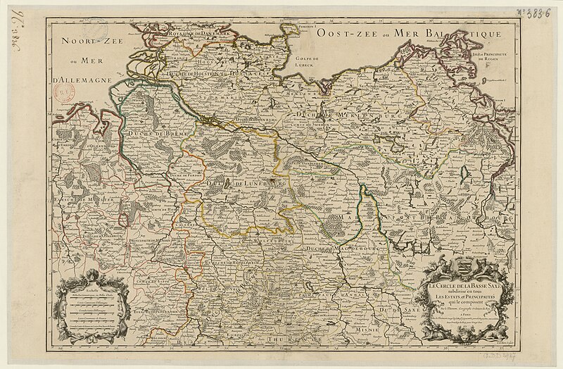
map of the circle of lower saxony by sanson
bibliothèque nationale de france
maps in the rijksmuseum amsterdam
maps by carolus allard
map collection of leibniz-institut für länderkunde
1690s maps of the iberian peninsula
old maps of austria
1695 books
bibliothèque nationale de france
sanson maps of asia
maps in the rijksmuseum amsterdam
1690s maps of belgium
l'espagne divisée by guillaume sanson
1690s maps of the iberian peninsula
maps of the course of the rhine by guillaume sanson
bibliothèque nationale de france
sanson maps of south america
south america in the 1690s
1690s maps of rhineland-palatinate
maps of east palatinate by sanson
prints of cartouches in the rijksmuseum amsterdam
maps in the rijksmuseum amsterdam
maps from university of amsterdam special collections
atlas der neederlanden
1696 maps of the caribbean
1690s maps of mexico
cartography
maps
maps from university of amsterdam special collections
atlas der neederlanden
france in the 1690s
old maps of france
mary ii of england in engravings
battle of the boyne
eran laor cartographic collection
pieter schenk (ii)
maps in the library of congress
hishikawa school,ukiyo-e
maps in the library of congress
hishikawa school,ukiyo-e
maps in the library of congress
hishikawa school,ukiyo-e
maps in the library of congress
hishikawa school,ukiyo-e
maps in the library of congress
hishikawa school,ukiyo-e
maps in the library of congress
hishikawa school,ukiyo-e
maps in the library of congress
hishikawa school,ukiyo-e
maps in the library of congress
hishikawa school,ukiyo-e
maps in the library of congress
hishikawa school,ukiyo-e
maps in the library of congress
hishikawa school,ukiyo-e
maps in the library of congress
hishikawa school,ukiyo-e
maps in the library of congress
hishikawa school,ukiyo-e
1690s maps of the ottoman empire
guillaume sanson
maps in the rijksmuseum amsterdam
maps by gerard valck
101 - 200 of 233
Next page
/ 3


![Hellas seu Graecia universa apud P[ieter] Mortier, 1690](https://cdn.creazilla.com/illustrations/10001021044/hellas-seu-graecia-universa-apud-pieter-mortier-1690-md.jpg)


![Titelblad] AFRICA](https://cdn.creazilla.com/illustrations/10000408184/titelblad-africa-sm.webp)


![The course of the river Rhine from its source to its mouth, where all the states and sovereignties above and in the surrounding area are distinguished. [Northern part] / by Mr. Sanson, between 1690 and 1699](https://cdn.creazilla.com/illustrations/10001103886/the-course-of-the-river-rhine-from-its-source-to-its-mouth-where-all-the-states-and-sovereignties-above-and-in-the-surrounding-area-are-distinguished-northern-part-by-mr-sanson-between-1690-and-1699-sm.jpg)